GIS Based Analysis of Land Use Dynamics in Bishkek
Ormukov, Ch.,1* Dyldaev, M.,2 Chymyrov, A.,3 Beishenkulova, M.1 and Gulkaiyr, T. K.4
1American University of Central Asia, 7/6 Aaly Tokombaev
Street, Bishkek, Kyrgyz Republic, 720060

2Bishkek State University named after K. Karasaev, Ch.
Aitmatov Avenue 27, Bishkek, 720044, Kyrgyz Republic

3Kyrgyz Technical University after I. Razakov, Ch. Aitmatov
Avenue 66, Bishkek, 720044 Kyrgyz Republic,

4Institute of Seismology National Academy of Science Kyrgyz
Republic, Asanbay 52/1, Bishkek, 720060, Kyrgyz Republic

*Corresponding Author
Abstract
Residents of urban areas experience a variety of difficulties as a
result of intensive urbanization, including clogged infrastructure,
air pollution, and waste management. Preservation of green spaces
provides a vital role in maintaining at least a minimum natural
balance for residents of urban area. Maintaining and preserving the
sustainable development of infrastructure is an important element
of urban planning. City planners thus face a difficulty in providing
urban dwellers with efficient and sustainable green spaces. Growing
problems in the field of land use and landscaping of urban areas
require an operational assessment of the existing situation. GIS
technology offers a powerful tool for assessing these issues and
developing solutions for sustainable urban development. A GIS-based
land use assessment can provide valuable information on the
distribution of urban land use types, which can help identify areas
of high land use intensity and potential for urban green space
development. The use of satellite imagery and other methods can
help track changes in land-use patterns over time, which can inform
urban planning and decision-making processes. Based on GIS analysis
and remote sensing, an assessment was made of changes in
territories and the distribution of green spaces in 4 urban
districts of Bishkek. These changes were assessed using LANDSAT 4-5,
LANDSAT-7, LANDSAT-8 and Sentinel-2 imagery. The evaluation
category included such areas as: parks, squares and street trees.
Areas with a level of green space coverage for different parts of
the city were identified by utilizing GIS technology to analyze the
spatial structures of green spaces. The spatial analysis also made
it possible to identify priority areas for the development of new
green spaces. For this study, we selected all ‘green’ areas within
the city of Bishkek. The southern region of the city is the most
interesting from the perspective of how the fabric of the city has
altered as a result of the elimination of green spaces. This
territory was originally designed taking into account the zone of
influence of the Issyk-Ata tectonic fault and developed to achieve
and comply with certain seismological standards. Our study thus
explores the characteristics of the growth of the city of Bishkek
over the previous few decades by providing information on the
distribution of land use types and green areas.
Keywords: GIS, Landsat, Sentinel, NDVI, Bishkek and
land Use
1. Introduction
Bishkek, the capital of the Kyrgyz Republic, experiences rapid growth
with a high demographic density similar to all the other cities of the
Central Asian Republics. Due to the dynamic growth of the urban
population, the city faces major environmental problems such as lack of
park areas, lack of water bodies, congestion of roads and solid waste
management. Bishkek is the capital of the Kyrgyz Republic with a
population of more than 1,145 million people [1].
In the Kyrgyz Republic, natural and historical processes and
established cultural and traditional features influenced the formation
of a specific form of urbanization. It differs from the classical type
by a relatively short historical period of about 100-150 years
(excluding ancient fortresses, mausoleums and caravan trading posts).
This distinguishes urbanization in the Kyrgyz Republic from worldwide
urbanization processes, the continuity of which has a thousand-year
history.
In the last twenty years, the pace of urbanization has become
spontaneous, around large cities (Bishkek, Osh, etc.) grew so-called
"new buildings", built up with low-rise houses without appropriate
infrastructure, which significantly worsened the
sanitary-epidemiological and environmental situation [2]. The strategic
development of Bishkek as the capital of the country and a major
agglomeration is inseparably linked to the overall course of
urbanization processes, and this indicator for the metropolitan region
should be indicative and sustainable.
As was reflected in the concept of long-term urban development of the
settlement system of the Chui region and Bishkek city itself for the
period up to 2025, which provides for integrated sustainable
environmental and economic development of architectural and planning
structure of the urbanization system of Bishkek agglomeration as an
area of influence with the core of Bishkek on other subsystems of
agglomeration impact. In the 1940ies, evacuated enterprises were placed
in Frunze and new industrial facilities were built, which influenced
the sprawl of the city, a series of expansion projects appeared. In
1970, a new master plan of Frunze was approved, the development of the
city went within the framework of the approved programs until the
collapse of the Soviet Union and the formation of an independent state
in 1991 and the renaming of the capital the city of Bishkek [2].
For the first time after independence, only in 2006, a new Bishkek
Master Plan was developed and built until 2025, where the boundaries of
the city, prospective areas of construction and vector of agglomeration
development were approved [3]. Analysis of statistical data enables to
assess the dynamics of changes in the areas of green spaces within
Bishkek for the 60-year period. As can be seen, from 1940 to 1975 the
area occupied by green spaces continuously increased, and by 1975
amounted to 1469 hectares. In the next 10 years (1975 - 1985) there was
a sharp reduction in the area of green spaces to 1050 hectares.
Subsequently, the area of green spaces changed little, and first in
2000 there was a sharp reduction to 856 hectares.
According to Kyrgyz State Design Institute of Urban Planning and
Architecture, the area of green spaces is about 500 to 600 hectares. A
sharp reduction in the area of green spaces is associated with their
displacement as a result of the construction of buildings and
structures on the territory of Bishkek. The level of green areas in the
total balance of the territory of the city has reached a catastrophic
figure - 28.44% in all categories of plantings, which is almost two
times lower than necessary (40 - 50%) to ensure normal sanitary and
hygienic conditions. There is a decline in the provision of public
plantations due to the growth of the population, the lack of new
plantings and the loss of existing ones. This indicator was 17.96
m2/per person on January 1st, 1997, however it was just 11
m2/per person on January 1st, 2005. The area of green spaces
per citizen in the last decade decreased from 78 to 68 m2.
Since 2014, 479 hectares of plantations have disappeared in Bishkek, and
only 250 hectares have been added. Now the city has only 9 percent of
its territory covered by green spaces, although the global
recommendation is 40 percent [4] and [5]. The quality of life in cities is
greatly influenced by the availability of attractive and easily
accessible green places; they are essential for recreation and for
mental and health recovery. In urban areas, green spaces play a
critical role in maintaining quality of life.
Residents' access to parks and open spaces is a major factor in the
livability of the city itself [6][7] and [8]. Little attention has
been paid to the natural environment close to where people live and
work, although it has been demonstrated time and again that green
spaces are extremely beneficial to citizens [9]. The planning and
management of green spaces is a complex task, especially in urban areas
with a dynamic population density [10]. Intensive urbanization in
developing countries is characterized by the absorption of agricultural
land, a process of rapid land use change. This process poses a serious
challenge for balanced and sustainable growth planning and expansion of
urban centers [11][12] and [13]. Currently, in Bishkek there are 3.5 m2 of green space per capita, and by world standards should
be 21 m2, that is, less than the put in 7 times, although
this figure in 1997 for Bishkek was 17.9 m2/person, which
was a total decrease of 5 times over a 25-year period [14].
2. Method
Urban greening is an important aspect of sustainable urban development,
aiming to improve the quality of life in cities by incorporating
vegetation and green spaces. GIS (Geographic Information Systems)
offers a powerful tool for assessing urban greening problems and
understanding their spatial characteristics [15]. This paper will
explore the application of GIS to assess urban green space problems,
highlighting its importance in solving problems and promoting
sustainable urban development.
Bishkek is a major city and the economic capital of the Kyrgyz
Republic. Bishkek is the capital and economic as well as population
center of Kyrgyzstan, and the city produces about 50% of the country's
total gross domestic product (GDP). Its significant economic importance
is primarily due to internal migration and its important geographical
position. The current estimated population of the city is about
1,145,000 people with a density of about 4600 people per km2 (Figure
1).
The population growth rate in Bishkek was approximately 90% from 1990
to 2023, and the population grew from 653,000 to 1.15 million in that
period. According to the statistical data the population of the city in
these little over 30 years has increased by about 60%, and thus in 2025
will reach 1,2 million inhabitants (Figure 2). However, according to
unofficial sources, the city's population has long exceeded 1.5 million
residents.

Figure 1: The location of Bishkek city
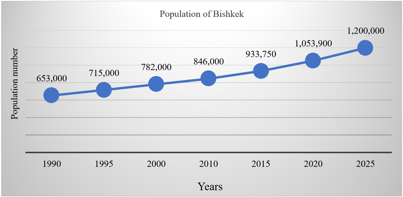
Figure 2: Bishkek population dynamics [1]
4. Results
4.1 Assessment of Land Use Dynamics
We assessed the dynamics of changes in the territory of Bishkek using
remote sensing. To perform this task, we used Landsat 4-5; Landsat 7;
Landsat 8 and Sentinel-2 satellite images for the last 30 years. As the
diagram shows the area of Bishkek in 1990 was 137 km2, and
then increased to 232 km2 by 2020 and according to master
plan Bishkek area will increase to 300 km2 by 2025 (Figure
3).
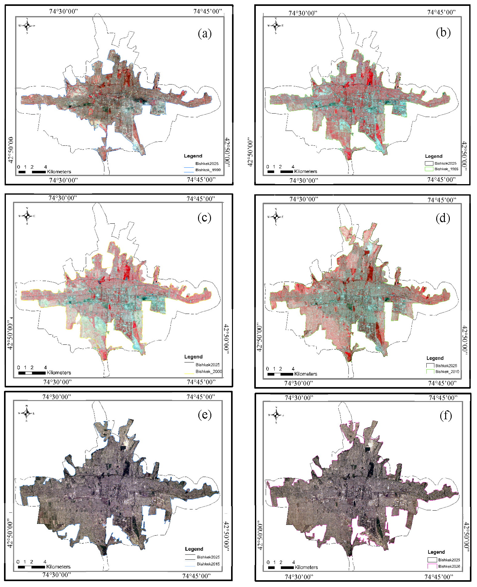
Figure 3: The dynamics of Bishkek territory changes
from (a) 1990, (b) 1995, (c) 2000, (d) 2010,(e) 2015, (f) 2020. The black polygon
is the Bishkek planning borders according to general plan of Bishkek administration by 2025.
The territory of the city during this period has expanded mainly due to
the development of adjacent areas, or more precisely due to the
transformation of agricultural land of Alamedin and Sokuluk districts.
In general, the city has expanded along the entire perimeter of the
inherited territory since 1990. However, the development of the
territories of the southwestern part of the city occurred at a faster
pace (Figure 3). The rate of expansion of the urban area has varied
with varying degrees of intensity and these expansions have varied
between 3.1 % and 18.0 % between 1990 and 2020. However, the latest
version of the city's Master Plan promises an even more dynamic rate of
urban expansion by 2025, where it will reach up to 22%. The rate of
population growth and urban expansion are shown in (Figure 4 and Figure
5).
4.2 NDVI
One of the main applications of GIS in assessing urban greening
problems is identifying and mapping areas with low vegetation cover or
limited green spaces [16][17][18] and [19].
Satellite images were utilized to investigate the expansion dynamics of
Bishkek city through the application of INDVI and GIS analysis. LANDSAT
4-5, LANDSAT-7, LANDSAT-8 and Sentinel-2 images and a GIS tool was used
to assess the dynamics of the area and its vegetation cover. This
information also provides a visual representation of areas requiring
intervention to improve greening. In order to analyze the ratio of
green space to building area, we used the well-known NDVI evaluation
method. For the clearest result, the decision was made to reduce the
percentage of cloud cover, which in this result does not exceed 10%.
Consequently, 1990, 1995, 2000, 2010,2015 and 2020 were chosen as the
years in which the clearest images were taken (Table 1). The NDVI
analyses were conducted over six observation times, encompassing time
intervals of every five years, except for the period between 2000 and
2010. Unfortunately, we were unable to find a reliable image for the
year 2005 during that timeframe. In general, this analysis includes the
period from 1990 to 2020 (Figure 6).

Figure 4: Dynamics of growth of the territory of the
city of Bishkek

Figure 5: Bishkek city area and population growth
dynamics between 1990 – 2025 and 1990-2020 respectively
Table 1: Satellite imagery acquisition dates
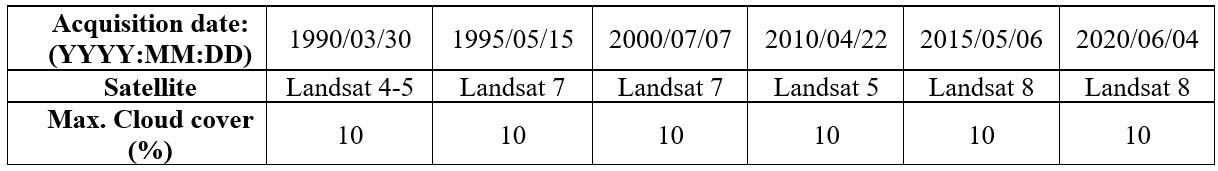
Figure 6: NDVI analysis result of Bishkek for different
time (a) 1990, (b) 1995, (c) 2000, (d) 2010, (e) 2010, (f) 2020.
Additionally, we conducted an analysis to examine the land use dynamics
in Bishkek using NDVI analysis. This approach enabled us to identify
and visualize vegetation-covered areas on the map, as well as detect
any unusual changes that occurred over time. In the period 1990-1995,
the vegetation of the city shows some anomalous areas with unhealthy
green spaces. According to the analysis in 1995, anomalous areas are
observed mainly in the park areas.
Beginning in 2000, the areas with green areas tended to deteriorate as
the adjacent areas were taken over by private construction. The last
two images from 2015 and 2020 show a sharp deterioration of the
vegetation cover along the entire perimeter of the city. While in the
early and mid-1990s we could observe some anomalous areas of unhealthy
background vegetation, over the past ten years we have seen a widespread
reduction in both adjoining and inner-city areas. Thus, during these 30
years, the Bishkek city administration has struggled to maintain the
integrity of parks located only in the central part of the city, while
in other parts of the city park areas have undergone severe changes.
4.3 Mapping of Parks
Currently, there is an intensive process of degradation of all large
and medium-sized park and forest-park zones. Forest parks and groves
are almost completely given up for individual housing construction, the
remaining forest park areas are slowly degrading. The park areas in
Bishkek have been gradually decreasing each year as a result of land
extraction for construction purposes. One specific example is Ata-Turk
Park and its surrounding areas, which have experienced significant
reduction since 2004. In 2005, the park's territory, including the
adjacent southern zone, was estimated to be approximately 350 hectares.
However, by 2010, the park had significantly diminished in size,
shrinking to only 131 hectares. Furthermore, based on digital images,
it was observed that the park's territory experienced an additional
reduction of 10 hectares in 2022. As a result, the current size of the
park is estimated to be 121 hectares.
The same situation is observed with Elm Grove Park at the beginning of
2005, the total area of the park was 253 hectares in 2009, and in 2020
the park area was reduced by another 10 hectares according to digital
surveys, so the current size is 121 hectares. The same situation is
observed with Elm Grove Park - at the beginning of 2005, the total area
of the park was 253 hectares in 2009, and in 2020 the park was reduced
to 150 hectares. The contours illustrating the reduction of the
aforementioned parks can be seen in (Figure 7 and Figure 8).

Figure 7: (a) Elm Grove Park which is located in
northern part of city and (b) Elm Grove Park area shrinkage map-scheme for over different periods
of time

Figure 8: (a) Ata-Turk formerly (Park Pobeda) which
located in southern part city and (b) Ataturk Park territory changing graph
5. Discussion
Based on the obtained data and the study's results, it is evident that
the urbanization trends affecting cities in the Central Asian region
exhibit distinct characteristics and share common developmental
challenges. Similar patterns were particularly prevalent in these
cities immediately after independence due to economic challenges, a lack
of funding for balanced city growth, and "false" urbanization, which in
some cases led to urban sprawl and violated the natural, architectural,
and environmental framework of cities and capitals generally. It has
been studied for 10–20 years, but only in the last 10 have many Central
Asian nations taken steps to optimize buildings and revitalize the
appearance of their cities.
Our investigation is primarily focused on the growth of the capital of
Kyrgyzstan because this tendency could not have gone unnoticed in the
city of Bishkek, leading to haphazard developments throughout the city.
Alongside the positive growth dynamics of the city of Bishkek,
including increased land use and population growth, there are also
challenges in terms of urban development, particularly in the new
suburban areas. Within the city itself, there is intensive construction
and increased building density, which leads to a disruption of solar
insolation, air circulation, and the formation of active smog zones.
Separate results showed that the specific types of land use in the five
capitals of the Central Asian Republics are related to the natural
landscape conditions around the cities. In general, pastures, unused
land and cultivated land are prevalent around these capitals. Water and
unused land are the landscape characteristics that shifted
dramatically, whereas the extent of land under development has
consistently increased [20][21][22] and [23].
6. Conclusion
Insufficient greenery: Our analysis has revealed a lack of greenery in
the urban structure of Bishkek due to dense construction. The research
results indicate that over the past 30 years, the city's territory has
increased from 137 km2 to 230 km2. The population
increased from 635,000 in 1990 to 1.15 million in 2023, and this growth
is anticipated to continue as the city continues to spread out along the
foothill plain and adds new residents each year. The city is
characterized by high building density and limited open spaces
allocated for parks, gardens, and recreational areas. This trend is
particularly noticeable in the central and southern parts of the city.
This lack negatively impacts the city's livability since greenery plays
a crucial role in providing environmental benefits such as improving
air quality and regulating temperature. Insufficient
forest cover: Our assessment has shown a low percentage of green cover
in Bishkek. Trees are essential for improving the urban environment as
they provide shade, absorb pollutants, and mitigate the urban heat
island effect.
The lack of sufficient forest cover exacerbates problems related to air
pollution, urban heat, and overall aesthetic appeal. In
Bishkek, there is an unequal distribution of vegetation, according to our
data. Central city districts have better access to parks and green areas
than the periphery and residential areas, particularly in the western and
eastern parts of the city. This inequality limits the fair distribution of
ecological benefits, affecting the quality of life for residents in less
green areas.
Reference
[1] Национальный статистический комитет Кыргызской Республики.
(n.d.). Открытые данные. Available:
http://www.stat.kg/ru/opendata. [Accessed May 16, 2023].
[2] Dyldaev, M.M., (2019). Suburban revolution" in the regional
section: the peripheral urban areas in the post-Soviet space: Collection of
abstracts of the international scientific conference. In 2 parts, Ulan-Ude,
November 14-16, / Editor-in-chief A.S. Breslavsky. - Ulan-Ude: Buryat
Scientific Center of the Siberian Branch of the Russian Academy of Sciences,
EDN QFIUOJ, 40-44,
http://doi.org/10.31554/978-5-7925-0571-1-2019-1-40-44.
[3] Официальный сайт мэрии города Бишкек. (n.d.).
История города
.
https://www.meria.kg/ru/history. [Accessed May 17, 2023].
[4] Dyldaev, M.M., (2012). The ecological condition of green areas
and plantations within the urbanized territories of the Kyrgyz Republic.
Science and New Technologies, Vol. 3, pp. 120-122. – EDN VRGGTZ.
https://www.elibrary.ru/item.asp?id=25738752.
[5] Study on the Improvement of Urban Transportation in Bishkek.
Kyrgyz Republic Final Report. Japan International Cooperation Agency
(JICA): Bishkek, 2013. pp. 79-85. Available:
https://openjicareport.jica.go.jp/pdf/12127585_01.pdf. [Accessed May 16,
2023)
[6] Hofmann, P., Strobl, J. and Nazarkulova, A., (2011). Mapping
Green Spaces in Bishkek—How Reliable can Spatial Analysis Be? Remote Sens.
3 (6), 1088-1103;
https://doi.org/10.3390/rs3061088.
[7] Fu, B., Yu, D., Zhang, Y., (2019). The livable urban
landscape: GIS and remote sensing extracted land use assessment for urban
livability in Changchun Proper, China. Land Use Policy Vol. 87, September,
104048.
https://doi.org/10.1016/j.landusepol.2019.104048.
[8] Schetke, S., Qureshi, S., Lautenbach, S., Kabisch, N. (2016).
What determines the use of urban green spaces in highly urbanized areas? —
Examples from two fast growing Asian cities. Urban For. Urban Green. 16,
150–159.
https://doi.org/10.1016/j.ufug.2016.02.009.
[9] Herzele, A.V.., Wiedemann, T., (2003). A monitoring tool for
the provision of accessible and attractive urban green spaces. Landscape
and Urban Planning volume 63, Issue 2, 15 April, 109-126.
https://doi.org/10.1016/S0169-2046(02)00192-5.
[10] Cheisura, A., (2004). The role of urban parks for the sustainable
city. Landscape and Urban Planning 68, 129–138. https://doi.org/10.10
16/j.landurbplan.2003.08.003.
[11] Halland, Ch., Konijnendijk, C., (2015). Challenges and strategies
for urban green-space planning in cities undergoing densification: A
review. Urban Forestry & Urban Greening Volume 14, Issue 4, pp.
760-771.
https://doi.org/10.1016/j.ufug.2015.07.009.
[12] by Lahoti, Sh., Kefi, M., Lahoti, A. and Saito, O., (2019).
Mapping Methodology of Public Urban Green Spaces Using GIS: An Example of
Nagpur City, India. Sustainability, 11(7), 2166;
https://doi.org/10.3390/su11072166
.
[13] ICLEI—South Asia. (2015). Green Growth Good Practices;
ICLEI—Local Governments for Sustainability, South Asia: Delhi, India,
Volume 3. Available:
https://gggi.org/wp-content/uploads/2017/11/2015-02-Urban-Green-Growth-Strategies-for-Indian-Cities-Volume-3-Green-Growth-Good-Practices.pdf. [Accessed May 19, 2023].
[14] Municipality// Popular Science Journal. (2023). Parks for All!
Zhyshyl Upgrade-21/ No. 3 (137) Available:
http://www.municipalitet.kg/ru/article/full/2578.html.
[15] Chen, X.-L., Zhao, H.-M., Li, P.-X., Yin, Z.-Y., (2006). Remote
sensing image-based analysis of the relationship between urban heat island
and land use/cover changes. Remote Sens. Environ. 104, 133–146,
http://dx.doi.org/10.1016/j.rse.2005.11.016.
[16] Lang, S., (2008). Object-based image analysis for remote sensing
applications: Modelling reality—Dealing with complexity. In Object Based
Image Analysis; Springer: Heidelberg/Berlin, Germany; New York, NY, USA,
1–25.
http://doi.org/10.1007/978-3-540-77058-9_1.
[17] Fei, Y., Marvin, E. B., (2007). Comparison of impervious surface
area and normalized difference vegetation index as indicators of surface
urban heat island effects in Landsat imagery. Remote Sensing of Environment
Vol. 106, 375–386.
http://doi.org/10.1016/j.rse.2006.09.003.
[18] Meng, L, Y., Zhang, Q. J., Zhang, L., Jancso, T., Vatseva, R.,
(2015). An effective Building Neighborhood Green Index model for measuring
urban green space. Int. J. Digit. Earth, Vol. 9, 387–409.
http://10.1080/17538947.2015.1037870.
[19] Lahoti, S., Kefi, M., Lahoti, A. and Saito, O., (2019). Mapping
Methodology of Public Urban Green Spaces Using GIS: An Example of Nagpur
City, India. Sustainability, Vol. 11, 2166,
https://doi.org/10.3390/su11072166.
[20] Zhang, X., Yao, L., Lou, J. and Liang, W., (2022). Exploring
Changes in Land Use and Landscape Ecological Risk in Key Regions of the
Belt and Road Initiative Countries Land, Vol. 11(6), 940;
https://doi.org/10.3390/land11060940.
[21] Salimova, Y.I., (2022). Urbanization and sustainable development
of urban areas of Uzbekistan Economic Bulletin. Vol. No.11, 85-89.
[22] Schröder, P., (2017). "‘Urbanizing’ Bishkek: Interrelations of
Boundaries, Migration, Group Size And Opportunity Structure: Central Asian
Survey: Vol. 29(4), 453-467 Tandfonline.com.
https://doi.org/10.1080/02634937.2010.537143.
[23] Falkingham, J., (2005) “The End of the Rollercoaster? Growth,
Inequality and Poverty in Central Asia and the Caucasus”, Social Policy and
Administration, Vol. 39(4), 340-360.
https://doi.org/10.1111/j.14679515.2005.00444.x.
